
Bagyong Sendong On The Making

Tropical Storm Sendong To Appear On November 2011
A Shallow Low Pressure Area (SLPA) was spotted below the Puerto Princessa, Palawan. The occuring weather threat has been affecting the entire country as it appear on the middle part of the Philippines, covering Visayas and had a reach on both Luzon and Mindanao areas.
Philippine Atmospheric, Geophysical and Astronomical Services Administration (PAGASA) had this report on their weather bulletin.
At 2:00 p.m. today, November 3, 2011, the Shallow Low Pressure Area (SLPA) was estimated based on satellite images and surface data at 130 kilometers Southeast of Puerto Princesa City (8.8°N, 118.0°E) embedded along the Intertropical Convergence Zone (ITCZ) affecting Southern Luzon, Visayas and Mindanao.
However, technically, the country had no official tropical cyclone yet.
PAGAS still raised the warning to the public to be vigilant to sudden floods and possible landslides.
If this weather become worsen and became an official tropical storm, it will be named as Bagyong Sendong - Tropical Storm Sendong as scheduled on 2011 Philippine typhoon list.
UPDATE: December 15, 2011
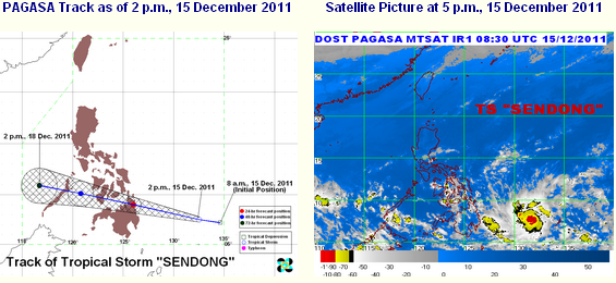
At 4:00 p.m. today, December 15, 2011, according to Philippine Atmospheric, Geophysical and Astronomical Services Administration PAGASA, Tropical Storm "SENDONG" was estimated based on satellite images and surface data at 610 kilometers East Southeast of Hinatuan, Surigao Del Sur (7.6°N, 132.0°E) with maximum sustained winds of 55 kilometers per hour near the center and gustiness up to 80 kilometers per hour. It is forecast to move West Northwest at 30 kilometers per hour.
PAGASA had raised the Public Storm Signal Number One to the following areas:
Luzon: None
Visayas:
Eastern Samar
Western Samar
Leyte Provinces
Camotes Island
Bohol
Mindanao:
Surigao Del Norte
Siargao Island
Surigao Del Sur
Dinagat Province
Agusan Provinces
Misamis Oriental
UPDATE: DECEMBER 16, 2011

Public storm warning signal has been raised on the following areas:
Signal Number 1 (45-60 kilometers per hour wind):
LUZON:
Palawan
VISAYAS:
Negros
Cebu
Bohol
Southern Leyte
Siquijor
MINDANAO:
Misamis Occidental
Lanao del Norte
Lanao del Sur
North Cotabato
Samal Island
Maguindanao
Davao del Sur
Zamboanga Provinces
Signal Number 2 (60-100 kilometers per hour winds) :
MINDANAO:
Surigao Del Norte
Siargao Island
Surigao Del Sur
Dinagat Province
Agusan Provinces
Bukidnon
Davao del Norte
Davao Oriental
Compostela Valley
Camiguin
UPDATE: DECEMBER 17, 2011

| Location of Center: (as of 4AM) | 20 kilometers West Northwest of Cagayan de Oro City |
| Coordinates: | 8.4°N, 124.4°E |
| Strength: | Maximum winds of 65 kilometers per hour near the center and gustiness up to 80 kilometers per hour |
| Movement: | Forecast to move West at 22 kilometers per hour |
| Forecast: | Sunday morning: 140 km Southeast of Puerto Princesa City Monday morning: 430 km West Southwest of Puerto Princesa City or out of the Philippine Area of Responsibility |
Signal Number 1 (45-60 kilometers per hour winds):
LUZON:
Palawan
VISAYAS:
Bohol
Siquijor
Southern Cebu
Negros Oriental
Southern Negros Occidental
MINDANAO:
Camiguin Island
Misamis Oriental
Bukidnon
North Cotabato
Maguindanao
Signal Number 2 (60-100 kilometers per hour winds) :
MINDANAO:
Misamis Occidental
Lanao del Norte
Lanao del Sur
Zamboanga Provinces
UPDATE: DECEMBER 18, 2011

| Location of Center: (as of 4AM) | 60 kilometers West Northwest of Puerto Princesa City |
| Coordinates: | 9.9°N, 118.4°E |
| Strength: | Maximum winds of 65 kilometers per hour near the center and gustiness up to 80 kilometers per hour |
| Movement: | Forecast to move West at 24 kilometers per hour |
| Forecast: | Sunday evening: expected to exit the Philippine Area of Responsibility Monday morning: 580 km West of Puerto Princesa City |
Public Storm Warning Signal was raised on the following areas:
Storm Signal Number One:
LUZON:
Cuyo
Coron Group of Island
Storm Signal Number Two:
LUZON: Palawan
Palawan
0 Comments :
Post a Comment