
Bagyong Sendong, Tropical Strorm Sendong, Typhoon Sendong - October 2011, Philippines

Bagyong Sendong Update, October 2011 - Philippines
The last typhoon, Bagyong Ramon, left significant damages to the already ragged provinces and cities by the the two previous typhoons before him. As Bagyong Ramon set to leave the country, it is expected that the next low pressure area which can become a tropical depression to a full pledge typhoon will occur this month of October.
With this, the next tropical storm that will hit the country will be named as Bagyong Sendong as set by the Philippine calendar of typhoon names.
Low Pressure Area
Tropical Depression Sendong Speed
Tropical Storm Sendong Location
Typhoon Sendong Direction
Bagyong Sendong
This post will be updated as soon as the Philippine Atmospheric, Geophysical and Astronomical Services Administration office (PAGASA) released any development about Bagyong Sendong.
More updates will be posted after this line.

UPDATE: December 15, 2011
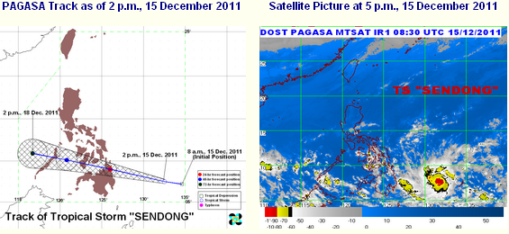
At 4:00 p.m. today, December 15, 2011, according to Philippine Atmospheric, Geophysical and Astronomical Services Administration (PAGASA), Tropical Storm "SENDONG" was estimated based on satellite images and surface data at 610 kilometers East Southeast of Hinatuan, Surigao Del Sur (7.6°N, 132.0°E) with maximum sustained winds of 55 kilometers per hour near the center and gustiness up to 80 kilometers per hour. It is forecast to move West Northwest at 30 kilometers per hour.
PAGASA had raised the Public Storm Signal Number One to the following areas:
Luzon:
None
Visayas:
Eastern Samar
Western Samar
Leyte Provinces
Camotes Island
Bohol
Mindanao:
Surigao Del Norte
Siargao Island
Surigao Del Sur
Dinagat Province
Agusan Provinces
Misamis Oriental
UPDATE: DECEMBER 16, 2011

Public storm warning signal has been raised on the following areas:
Signal Number 1 (45-60 kilometers per hour wind):
LUZON:
Palawan
VISAYAS:
Negros
Cebu
Bohol
Southern Leyte
Siquijor
MINDANAO:
Misamis Occidental
Lanao del Norte
Lanao del Sur
North Cotabato
Samal Island
Maguindanao
Davao del Sur
Zamboanga Provinces
Signal Number 2 (60-100 kilometers per hour winds) :
MINDANAO:
Surigao Del Norte
Siargao Island
Surigao Del Sur
Dinagat Province
Agusan Provinces
Bukidnon
Davao del Norte
Davao Oriental
Compostela Valley
Camiguin
UPDATE: DECEMBER 17, 2011

| Location of Center: (as of 4AM) | 20 kilometers West Northwest of Cagayan de Oro City |
| Coordinates: | 8.4°N, 124.4°E |
| Strength: | Maximum winds of 65 kilometers per hour near the center and gustiness up to 80 kilometers per hour |
| Movement: | Forecast to move West at 22 kilometers per hour |
| Forecast: | Sunday morning: 140 km Southeast of Puerto Princesa City Monday morning: 430 km West Southwest of Puerto Princesa City or out of the Philippine Area of Responsibility |
Signal Number 1 (45-60 kilometers per hour winds):
LUZON:
Palawan
VISAYAS:
Bohol
Siquijor
Southern Cebu
Negros Oriental
Southern Negros Occidental
MINDANAO:
Camiguin Island
Misamis Oriental
Bukidnon
North Cotabato
Maguindanao
Signal Number 2 (60-100 kilometers per hour winds) :
MINDANAO:
Misamis Occidental
Lanao del Norte
Lanao del Sur
Zamboanga Provinces
UPDATE: DECEMBER 18, 2011

| Location of Center: (as of 4AM) | 60 kilometers West Northwest of Puerto Princesa City |
| Coordinates: | 9.9°N, 118.4°E |
| Strength: | Maximum winds of 65 kilometers per hour near the center and gustiness up to 80 kilometers per hour |
| Movement: | Forecast to move West at 24 kilometers per hour |
| Forecast: | Sunday evening: expected to exit the Philippine Area of Responsibility Monday morning: 580 km West of Puerto Princesa City |
Public Storm Warning Signal was raised on the following areas:
Storm Signal Number One:
LUZON:
Cuyo
Coron Group of Island
Storm Signal Number Two:
LUZON: Palawan
Palawan
UPDATE: DECEMBER 19, 2011

speechless...
ReplyDelete